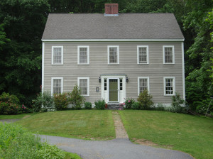
19 Acres:
1745, Nov 27: John and Sarah Swett to Simeon Brown (Physitian) (87/139) near Swett’s Ferry : bounded easterly on the road that is laid out from the landing to the road that leads to Merrimack River near the XXXX XXX between Haverhill and Amesbury. Northerly on the highway leading from Jamaica Path to the said XXXX XXX, westerly on Jamaica Path, southerly partly on landing and partly on the county road that leads to said Swett’s Ferry. 19 or so acres
1745 (recorded): Simeon Brown to James Bowdoin. Same land as above (Mortgage) Paid off (132/17 between Henry Young Brown and William Bowdoin 1773, June 30th)
1773, July 3: Henry Young Brown, Ruth Brown, and Simeon Brown to James Carr (134/22). 19 Acres. Bounded northerly on starting at bound rock and road leading to Jamaico path, westerly by Jamaico path, southerly by highway that leads from Kingstown to Swett’s ferry in part on landing, easterly by 2 rod way to bound first mentioned.
1774, Sept 7: James Carr innholder To Francis Carr of Almsbury, cooper, 19A dwelling house all other buildings bounded by highway west(?) from bound rock to Jamaica path then s on Jam path to road from Kingston to Swetts ferry then on said road e to Ephraim Elliots upon said road then on Elliots n to s&s then Elliots s to the road or landing then on landing e to a 2-rod way Swett allowed then on said way n to the way from bound rock to Jam path (start). 134/ 23
3 or 4 acres
1805, July 11: Francis Carr to Frederick Parker (Tanner). Four acres of land for $500. (179/109) 27R easterly along Swett’s Road then westerly along Cutting’s Lane (Back Lane) 13R, then southerly and westerly along curve by land of Carr as the wall now stands about 22R, then southerly by Carr’s land as the fence now stands about 5R then easterly about 9R by land of John Johnson Jr. containing about 4 Acres. This adjoins this land to 38 East Main.
Joseph Estabrook marries Ann Parker (potentially Frederick’s Sister). In Frederick’s probate # 20499 all his land was split between his wife Abigail, Sister Ann (Nancy) and mother Ann (Nancy)
1835: Apr 18: 282/92: Joseph Estabrook and Ann Estabrook Estate to Charles Minot bounded by Fullington, Enoch Foot, and Poyen, considered a yard bark. Charles Minot is listed as a Counselor/Attorney in 1847 Haverhill. (mortgage)
1835, Mar 5: goes back to Joseph Estabrook?? Including 2 other pieces of land.
1840, Jan 17: Joseph Estabrook to William Ashby. (316/258). five acres and two dwelling houses on north side of road leading from Rocks Village to Haverhill Town. Beginning at southeasterly stake and stone on corner of road and Ebenezer Fullington, running North by land of Fullington, Easterly by land of John Johnson to a road. Northerly by road to Back Road. Westerly by Back Road to land of John Johnson Jr. Then Southerly by land of Johnson to Road and first point. Mortgage: 497.70 to be paid within 1 year with interest.
1861, Feb 25th: From Joseph Estabrook Jr. to John R. Estabrook (brother)(618/110) Upon Joseph Sr. death. This contained 8 acres and was considered Joseph’s homestead.
1867, Apr 29: Ann M Estabrook (John R’s wife), J. L. Estabrook (son) and Mary E. Estabrook (daughter in law) to Lydia A. Davis (727/138)
1868, March 30: Lydia A. Davis to Andrew J. Young (743/157) Two pieces of land: 1. on River Road bounded by Abigail George, Elliott, Hayden Brown, Road leading from Rock’s Village to South Amesbury, Ann M. (or could be W.) Estabrook (20 River), John Osgood (12 River Road), James Davis, and John B. Nichols (either Tavern or Sawyer Store) 2. Bounded northerly by merrimac river, northerly by land of James Pecker, southwesterly, and south easterly by highway (34 Wharf Lane)
1870, Sept 20: Mortgage to Moses Brookings (806/273) bounded by Abigail George, Hayden Brown, road from RV to So. Amesbury, Charles Carr, John Osgood, Davis, and J. B Nichols. (discharge 817/35)
1871, Feb 17: Andrew J. and Harriet H. Young to Five Cents Saving Bank (817/35) mortgage discharge (1081/94)
1888, Nov 1: Andrew J. Young to C. B. Young (1240/233)
1889, Dec 10: C. B. Young to Andrew J. Young (1273/16)
1892 Map lists A. Young
1894, July 30: Andrew Young to John N. Hunkins and Flora A. Hunkins (1419/35) 5 acres
1905, Sept 6: Hunkins to Merrimac Savings Bank (1791/409) 5 acres
1912, Nov 27: Merrimack Savings Bank to Augustus I. Bragdon (2186/290) (2186/292 mortgage)
1930, Mar 24, Augustus I. Bragdon to Andrew O Nicol
1930, March 26: Andrew O. Nicol and Mary H. Nicol to Merrimack Valley Development Corp (2839/387) (mortgage?) about 5 acres
1948, Nov 30: Merrimack Valley Development Corp. to Carroll L. Barton (3546/588) about 5 acres
1959, Sept 14: Joan Bancroft To Carroll L Barton and Mary A. Barton(4599/39) – about 5 acres. Included 38 E Main Street.
1989, Feb 9: Jerry Leiske to John K. Muese (9890/337)
1992, March 6: John K. Muese to Muese (11172/532)

1994, April 25, John K. Muese and Arlene B. Muese to Campbell (12540/57)
1997, March 4: Joseph P Campbell and Joan M. to Michael W. Forehand and Lydia A. Harris (14031,2)