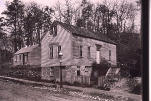
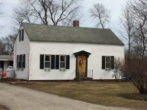
1821 Enoch and Dolly Foot to Amos B. Chase (227/249). Bounded on west by Enoch Foot (6R), north by Col. John Johnson (2r 18L), East by Enoch Foot 6R, Highway on south 2R, 18L. Lot of land with Buildings.
1825: Amos B. Chase to Benjamin Chase (No4/245) 5 rods along E. Foot, 3 Rods along Amos B. Chase, 5 rods along Amos B. Chase, 3 rods along road.
1826: Amos B. Chase and Mary Chase to Amos Morse (240/128). Bounded on West by Enoch Foot (6R), north by Col. John Johnson (2r 18L), East by Enoch Foot 6R, Highway on south 2R, 18L. Lot of land with Building.
1834, June 17: Amos (son of Daniel/Mary Challis) and Lucretia Morse to Samuel Sewell Chase (276/143). Bounded on West by Enoch Foot (6R), north by Col. John Johnson (2r 18L), East by Enoch Foot 6R, Highway on south 2R, 18L. Lot of land with Building
1842, Oct 4: Samuel Sewall Chase (son of Moses Chase and Mary Noyes) and Eunice Noyes (Colby) Chase of West Newbury to Abigail Elliott (widow) (487/70) $120.00 Bounded on East by Enoch Foot (6R), north by John Johnson Jr. (2R, 10L), South by road 2R, 10L, westerly by Jacob G. Nichols (6R). Parcel of land with Buildings.
1850 map lists Mrs. A. Elliott
1855 Census: (listed next to Samuel and Sophia Elliott)

Abigail Elliott (62)
Mary J. Elliott (32)
Annett Elliott (28)
George Elliott (26) Shoe....
Thomas J. Orne (24) Shoe.....
1865 Census:
Abigail Elliott (76) housewife – head of household
Mary J. Elliott (43) stitcher
George H. Elliott (20) student
1870, Nov 8: Samuel Elliott, George G Elliott, Adeline Brookings, Mary J. Elliott. Mary C. Elliott, William Sawyer & Anette Sawyer, George E. Elliott, Sophia A. Elliott, and M. P. Brookings to Joseph Emond (818/65) $600.00. Bounded by road on south (2R 10L), John B. Nichols on west (6R), John Johnson Jr. on North (2R 10L), and E. Foot (6R) on east. Being the same land conveyed to Abigail Elliott from Samuel Chase (487/70)

There was a small house on land above the “Tavern” that was moved to Amesbury Line Road. Potentially moved after Abigail Elliott dies.

1870 Mortgage (811/38) Emond to Moses P. Brookings (Adeline (Elliott) is his wife) Being the same premises conveyed to me by Samuel Elliott.
(1874 discharge by Lizzie M. Brookings (1267/287)
1883, Apr 13: Samuel T. Ordway marries Mary A. M. Banks (daughter of William Banks and Catherine Banks??)
1889, Dec 5: Joseph P. Emond and Mary E. Emond to Samuel T. Ordway (1265/393). Starting on corner of E. Foot and main road, running north to land of Johnson then west to land of to land of J. B. Nichols, then south to road and easterly back to beginning. Being same land conveyed to Emond by Samuel Elliot and other by deed dated Nov 8 1870. Mortgaged in 1874 by Emond 811/38.
Joseph Emond gives life tenancy to Sumner Woodman and Mary B. Woodman. $100/year for the first four years and $1.00 per year after that.
1892 Map lists S.T. Ordway
1900 Census
Samuel Ordway (37)
Mary A. Ordway (36)
1903 both 18 and 20 east main combine to make 20 east main
1903, Apr 22: Samuel T. Ordway and Mary A. M. Ordway to George W. Jaques (1703/517) Bounded south by road, north by formerly Johnson, West by formerly John B. Nichols, east by Enoch Foot. (same as 1265/393)