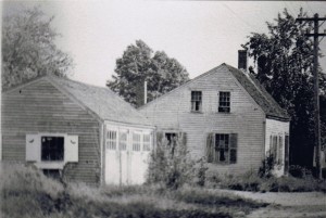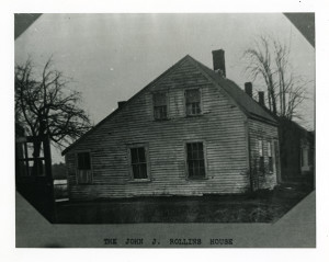
This parcel is located on the river side of Wharf Lane between the Bailey/Brown barn at 1 Wharf Lane and the Noce house at #20. It no longer has a house on it. The house that was originally there, the John Rollins house, was destroyed by fire in about 1957 or 8. The land currently belongs to the owner of the house directly across the lane. The parcel is sometimes listed as #14.
John Johnson Rollins, a comb maker from West Newbury, in 1830 bought a plot of land from the heirs (daughters) of Zebulon Ingersoll (257,152). The heirs included Nathaniel and Sally (Ingersoll) Ladd, Enoch and Dolly (Ingersoll) Foot, John and Ruth (Ingersoll) Johnson, and Samuel and Betsy (Ingersoll) Foot. The parcel was located on Wharf Lane between the Ingersoll house (1 Wharf Lane) and #20 which belonged to the heirs of John Ingersoll (son of Zebulon). See also the page on 4-8 Wharf Lane.
Between 1830 and 1836 Rollins appears to have obtained loans from various neighbors by deeds and notes involving sections of this land, one section to a combination of Enoch Foot, Benjamin Chase and John Johnson (262,268); another to George Foot – including “buildings thereon” (266, 90), and another to Enoch Foot, also including buildings (262, 114). In 1836 he sold the land to Col. Johnson (304, 52). It is likely that it is during this period (1830-1836) that he built the house known as the John Rollins house, on the #10 land, near the lane.
This John Rollins’ full name is John Johnson Rollins. His wife was Sarah (Paige). He was the son of John J. Rollins who was married to Betsey (Johnson), Col. Johnson’s sister. By the time these land transfers were occurring, the elder John Rollins had died (1818). John the younger was about 30 years old. John I. Rollins is listed as a Comb Manufacturer (this is son of John Rollins and Betsey (Johnson)) in the 1830 census.
Rollins moved to Bradford about 1836 and remained there the rest of his life. (I think he really moved to Salem but he is listed in Haverhill 1830 census, see below).
We pick up the trail again on this property in 1852 when John Johnson and Ruth Johnson sold the parcel with a “cottage dwelling house” to Charlotte P. Chase (504/106). Charlotte was born Charlotte Cooper, and the house was destined to remain in the Cooper family for more than one hundred years. An 1850 map shows the resident of the house as J.J. Chase. Benjamin Chase wills a “one story store” in Rocks Village. The 1850 Haverhill census lists John Chase, shoemaker, age 37, and his wife Charlotte of Amesbury, married in 1839. John Johnson Chase was the brother of Eutis Chase, Mary Jane Fullington, and Eliza Hall (all children of Benjamin Chase and Betsy Ladd)
In 1869 Charlotte P. Chase (now the widow of John Johnson Chase) sold the property to her brother, George S.Cooper (Engineer) for $425.00 (767/283) The 1850 census had listed a George S. Cooper, 25, joiner. An 1892 map lists G. S. Cooper as residing in the house.
The 1900 census lists Albert W. Cooper, age 54, his wife Mary and his father George S. Cooper, age 76, as residing in the house. In 1922 the administrator of the estate of George S. Cooper transferred ownership to his son, Albert W. Cooper (2504/286).

Sometime between 1922 and the 1930’s the Coopers must have sold it to their daughter Ida Cooper Smith. A map made by the Sweeneys of 1 Wharf Lane in the 1930’s shows the owner of the property as Ida Smith (widow of Frank H. Smith). The 1940 Census considered the address to be 14 Wharf Lane, with Ida Smith, age 67, living there. Ida M. Smith is the mother of Frank A. Smith Sr. who owned the Toll Keeper’s House in its new location at 27 River Road and where later his son Frank S. “Red” Smith owned and resided with his family for many years. See also Cooper family page.
An electrical power lawnmower spark caused fire on the front corner of the house 1958. Frank Einer, who lived next door, tour the house down.
In 1966 Frank A Smith Sr., administrator of Ida Smith’s estate and Albert W. Cooper’s estate, sold the property to James Bulgaris and Blanche A. Bulgaris(5351/465), ending a long line of Cooper/Smith ownership. The Bulgaris family owned and lived in the house across the lane at #19.
1976 James Bulgaris, unmarried, sold it to J. Bulgaris and Blanche Bulgaris (6294/744)
In 1994 Blanche A. Bulgaris (widow) sold the parcel to Ricky C. Stanichuk (12714/293). In 2010 Jason Stanichuck (Ricky C. Junior Realty Trust)to Ricky C. Stanichuk (29787/63).
Deeds:
1789, Sept 23: James White to Dolly Ingersoll (Zeb’s Sister) (150/213). Beginning at stake and running 8R along landing to Flats of Merrimack River 18R, west by 10.5 R by land of White, then northerly by land of White 4R to a 2 rod-way, north on way 4R, then easterly 0.5 rods then northerly 8R to beginning point. (includes 1 Wharf lane)
1803, Oct 1: Dolly Greenleaf to Zeb Ingersoll (173/67). A house with 1 acre of land bought from James White. Starting at 2.5R way and running east along landing to River 8R. Then 18R southerly along River, then westerly 10.5R along N. Ladd, then northerly along Daniel Swan land 4R, then continuing north along 2 Rod way 4R then easterly 0.5R Rods, then northerly 8R to bound first begun. (includes 1 wharf lane)
1812: Zebulon Ingersoll to John Ingersoll (198/73) Running from N. Ladd north along Daniel Swan’s land 4R to land of Zeb. Then easterly along Zeb to River 10R, then southerly along River for 4R to N. Ladd, along westerly by N. Ladd to bound first mentioned.
1830: Zebulon’s heirs: N. Ladd and Sally (Ingersol) Ladd, E. Foot and Dolly (Ingersol) Foot, John Johnson and Ruth (Ingersol) Johnson, and Samuel C. Foot and Betsy (Ingersol) Foot to Rollins (257/152). Starting at corner of John Ingersoll Esq land and running north along way 10R, then easterly 6R, then northerly 3R, easterly by town landing to Merrimack River Flats, south 14R then westerly 10R to bound first mentioned. (includes 1 wharf).
1830, May 20: John J. Rollins and Sarah J. Rollins to John Johnson, Enoch Foot, and Ben Chase. (262/268) running 9R along land of Rollins to land of heirs of John Ingersoll then northeasterly about 3R to landing then along landing to River. Down river 12R to land of Rollins then easterly along Rollins about 9R to bound first mentioned (this is land closest to river 4-8-10/14 Wharf)
1831, Apr 14: John J. Rollins to Enoch Foot. Land and buildings (262/114). bounded on west by wharf lane 10R, north by land of John Ingersol Esq. heirs 6R, East by land owned by E. Foot, B. Chase, and J. Johnson 10R and South by heirs of Ingersoll 12R, south by land of John Ingersol Esq. back to beginning on lane.
1831, Aug 27: John J. Rollins and Sarah J. Rollins to George Foot (266/90). A certain parcel of land with 2 building containing about 1/2 acre and bounded: Running northerly 10R along Road, 6R along land of heirs of Ingersoll, 8R south along land of Johnson, Foot, Chase land, then easterly along same land to River, Southerly along river 6R, then easterly along land of John Ingersoll, Esq. (son of Zeb) Deceased. (Mortgage)
1852, May 14: John Johnson and Ruth Johnson sold the #10 parcel with a “cottage dwelling house” to Charlotte P. Chase (504/106) (bounded by road, Johnson, Timothy Kinison, with 64 feet on the lane) Doesn’t say anything about River.
1853: Charlotte got a mortgage from Moses Brookings for this land (472/82, discharged 515/76 in 1855)
1856: map lists J. J. Chase
1850 Census
881-1108  John CHASE, 37, shoemaker
          Charlotte P.(Cooper)", 30
          Maria ", 9

Eustis S. [J. GR5], s. John I. and Charlotte P., drowning, June 6, 1849, a. 7 y. 6 m.
John and Charlotte married  sept 10, 1839
1850 Census
883-1110  George S. COOPER, 25, joiner
          Maria (Quested) ", 22, ENG
          Albert W. ", 3
          Charlotte ", 2
He lived in a different house in 1850 (which one? Is he renting?)
George S. Cooper marries Maria Quested, int. Nov. 8, 1846.
Albert W., s. George S., b. Amesbury, carpenter, and Maria, b. England, Dec. 2, 1849.
1855 Census (next to Rufus K. Knowles on census)
Lydia L. Fowler (38)
Martha J. Chase (25)
Henry H. Chase (4)
Charles F. Chase (3)
John F. Fowler (16)
1855 Census (next to Fowler)
Luke Jackson (56) Barber
Susan Jackson (39) Connecticut
Johanna Murphy (11) Ireland
Feb 10, 1869: Charlotte P. Chase (Widow of John Johnson Chase) to George S.Cooper (Engineer) for $425.00 (767/283) her brother. West 64′, North by land of Dean Morse and Sweeney 148′, 64′ by the River, North by Kinneson and Harrington.
1870: George S. Cooper is listed as Carriage Maker, working at Foster’s Factory and living on Wharf Lane, Rocks Lane
1870 Census:
Albert W. Cooper (22) works in shoe factory
Mary E (26)
Elmer Bradley (4) at home
1892 map lists G. S. Cooper
1900 census:
Albert W. Cooper, 52 shoe maker (b Dec 1847)
Mary – 55
George S. (Father) – 76 (born July 1823) Carpenter
1922, Feb 23: administrator Edward B. Germain) to Albert W. Cooper (2504/286) probate 148257 West 64′, North by land of Dean Morse and Sweeney 148′, 64′ by the River, North by Kinneson and Harrington.
1940 Census: considered 14 Wharf Lane: Ida Smith – 67
Ida M. Smith – burned down in 1957-58 (Ida M. Smith is the mother of Frank Smith who owned the Toll Keeper’s House in its new location of 27 River Road)
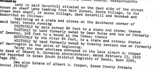
1966, April 6: Frank A. Smith Jr. to James and Blanche Bulgaris (5351/465) Probate 286214 West 64′, North by land of Dean Morse and Sweeney 148′, 64′ by the River, North by Kinneson and Harrington.
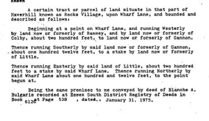
to 1975, Jan 31: Blanche Bulgaris to James Bulgaris (6126/537) West 64′, North by land of Dean Morse and Sweeney 148′, 64′ by the River, North by Kinneson and Harrington.
1975, Jan 31: James Bulgaris to James and Blanche Bulgaris (6294/744) West 64′, North by land of Dean Morse and Sweeney 148′, 64′ by the River, North by Kinneson and Harrington.
James Bulgaris (d Dec 4, 1993)
1975/1976:


1994: Blanche A. Bulgaris (widow) to Ricky C. Stanichuk (12714/293) West 64′, North by land of Dean Morse and Sweeney 148′, 64′ by the River, North by Kinneson and Harrington.
1996: Jason Stanichuck (Ricky C. Junior Realty Trust) (29787/63) to Ricky C. Stanichuck.
References
https://haverhill.pastperfectonline.com/photo/7A0313AA-ADFE-4801-ABD6-541322465470